camping

Road Trip To: Vogel State Park

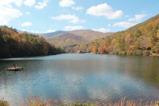
Nestled in the heart of the Chattahoochee National Forest, Vogel State Park is one of Georgia’s favorite destinations. Established in 1931, Vogel, is the second oldest state park in Georgia and rises 2,500 feet above sea level. The entire area around Vogel was once linked to the Native Americans and the State Park sits at the base of Blood Mountain, the highest summit on the Appalachian Trail in Georgia. Driving from the south, visitors pass through Neel Gap, a beautiful mountain pass near Brasstown Bald, which is the highest point in Georgia. The history of the “Vogel” name starts in the 20th century when Augustus Vogel and Fred Vogel Jr. began a lumber mill in Union County. The mill employed many of the men in the county to cut and process lumber from the 65,000 acres of land owned by the Pfister Vogel Leather Company. Unfortunately, the state of Georgia entered an economic downturn in the mid-1920’s and the lumber mill was no longer economically feasible. In 1929 the Vogels donated nearly 259 acres to the state, much of it still encompassed within the 233-acres within Vogel State Park. This park shares a timeless connection with its Civilian Conservation Corps builders that dammed Wolf Creek to form Lake Trahlyta and built housing around the lake for the CCC boys. The 22-acre Lake Trahlyta is named for the Cherokee maiden whose grave sits at the center of Stonepile Gap. The rest of the land donated by the Vogels is under the Chattahoochee National Forest and includes the stone building now known as Mountain Crossings at Walasi-yi and Nottla or Nottely Falls, east of the Byron Herbert Reese Trail parking lot. Originally, Walasi-yi was a restaurant run by the state. Directly by Vogel is the Byron Herbert Reece Farm and Heritage Center that celebrates the life of this famous poet who received numerous awards for his writing. The center has wonderful displays, restoration of the Reece writing studio, authentic farm buildings and equipment, plus self-guided tours. Vogel State Park offers a variety of hiking, swimming, fishing and enjoying family time in a diverse mountain landscape. An easy 1.0 mile hiking trail circles the lake, allowing access to fishing docks and the boathouse. A 0.1 miles side trail takes hikers down to Trahlyta Falls, also know as Spillway Falls. A spur trail off the Trahlyta Lake Loop will take you down to an observation deck at the bottom of the roaring falls! More experienced hikers may enjoy the popular 4-mile Bear Hair Gap and the challenging 13-mile Coosa Backcountry Trail. Helton Creek Falls can be found just minutes away from Vogel. There are two waterfalls to see — the lower and upper falls — and the hike is a short, family-friendly 0.6 miles. If you’re looking for another nearby waterfall hike for the whole family, look no further than DeSoto Falls! The DeSoto Falls hike also takes you to two waterfalls, and has a beautiful picnic area. Cottages, campsites and primitive backpacking [...]

Road Trip To: Vogel State Park2025-06-18T15:24:04-04:00

and the Chattahoochee River runs through it…

Many people know the Chattahoochee River as one of the most important U.S. Army Corps of Engineers impoundments in the nation. This river’s basin is the smallest in the nation and serves as a source of drinking water for metro Atlanta, and continues along the Georgia – Alabama border, and into Florida. This important source not only provides drinking water supply to more than half of all Georgian residents, but also provides hydroelectric power, commercial navigation, flood control, and recreation in three states to over 25 million Americans. It begins as a spring; “Chattahoochee Gap,” just a little more than a trickle of water where Jack’s Knob Trail dead-ends into the Appalachian Trail at about 3,600 ft. and lies 200 ft. south. Several streams flow from Habersham, Lumpkin, Rabun, Towns, Union and White counties to broaden its shoulders. Origin of the name “Chattahoochee” is believed to be derived from ‘Chatto,’ a stone, and ‘hoche,’ marked or flowered; there being rocks of that description in the river above Hoithletigua - an old town that historians place near the present town of Franklin, Ga. in Heard County. The river, “Chota,” was named by the Cherokee Indians at the headwaters and when the river flowed into Creek territory, it became the “Chattahoochee.” and was used by the tribes as a border between their Nations, then between themselves and early settlers. Excavations suggest that Spanish searched for gold in the valley as early as the sixteenth century. The first American gold rush began in 1828 through streambeds of the Chattahoochee headwaters, and the first dam was built to power a grist and lumber mill in 1876. The present Nora Mill still operates a water-powered mill and grinds cornmeal, grits, wheat, rye, and flours. The Chattahoochee River and Wildlife Management Area are located within the 750,000-acre Chattahoochee National Forest with lush forests. More than 500 species of birds, mammals, fish, and reptiles live in this protected headwaters portion, as it provides wildlife access to drinking water, sites for nests and dens, and berry-producing shrubs along its banks as a source of food. Helen is a perfect start, as this river runs through this Alpine Village town of themed German- festivals and businesses. Then the Chattahoochee picks up flow from creeks such as Smith, Low Gap, Henson, Dukes, and Sautee. Two beautiful waterfalls that merge into these creeks are the twin falls of Anna Ruby and Horse Trough Falls, just north of Helen. From Helen, the river flows east through Sautee Nacoochee Valley, which pass agricultural-residential areas throughout White and Habersham Counties. The river then flows into Buck Shoals State Park, a wildlife preserve not yet opened to the public and Mossy Creek State Park just north of Clermont. The river flows through the newly planned State Park (Don Carter) on the northern tip of Lake Lanier. Summer is the perfect time to enjoy recreation such as fishing, tubing, canoeing, boating, hiking and camping on the Chattahoochee River banks, shores, and it’s watershed to make your [...]

and the Chattahoochee River runs through it…2025-06-18T15:24:23-04:00
Go to Top