
Road Trip to Brasstown Bald
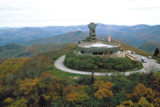
From Atlanta, GA 102 mi From Chattanooga, TN 117 mi From Asheville, NC 121 mi From Greenville, SC 117 mi The mountain of Brasstown Bald is known to the native Cherokee people as Enotah. It is named for the former Cherokee village of Brasstown, Georgia, located along the upper Brasstown Creek. In addition, across the N.C. state line, is Brasstown, North Carolina, in Clay County. (Brass). Itse’y, New Green Place, is a Cherokee locative name given to several distinct areas, and legend tells of a great flood that swept over the land. Everyone who inhabited the land died except a few Cherokee families that sought refuge in a giant canoe. The canoe ran aground at the summit of the mountain. Having no wild game to hunt and no place to plant, the Great Spirit killed all of the trees on the top of the mountain so the surviving people could plant their crops. While the Cherokee legend tells of a treeless mountaintop, the term “bald” is common mountain terminology for mountaintops that have 360-degree unobstructed views. Several trails that lead up to Brasstown Bald, including Wagon Train Trail and Jack’s Knob Trail, where there is an access path to the Appalachian Trail. Arkaquah Trail follows high ridges to the Track Rock Archaeological area, and Brasstown Bald Trail climbs 500 ft. in a half mile. At the top, a stone building was built in the late 30’s and Arthur Woody still greets visitors to the tower that he conceived. Today the present stone structure sits near the location of the original tower and houses a museum and exhibit entitled “Man and the Mountain.”Visitors can travel to Brasstown by car, from State Rd. Hwy. 180 that can be accessed either coming from Helen or Hiawassee on 17/75 or by Blairsville on Hwy. 129. Once at the parking facility, there is a steep, paved trail to the Visitor Information Center at the summit. Although difficult, this is an excellent hike for most people. Frequent stopping places along the path make it achievable for even the most out-of-shape hikers. A shuttle in the visitor parking lot provides access to the summit, and a picnic area for the public. The Visitors Center provides an unencumbered 360 view of the surrounding mountains and four states of North Carolina, Tennessee, Alabama, and South Carolina. As part of the Blue Ridge area of the Appalachian Mountains, Brasstown Bald is 4,784 feet above sea level and is the highest point in North Georgia. Plan on viewing the extensive museum and various presentations on forestry in North Georgia, as it is well worth the time. Brasstown Bald is Open Daily 10:00 – 5:00 from May to October and on weekends through November. For more info contact: Blairsville Ranger Office: 706-745-6928 or Brasstown Bald Visitors Information Center: 706-896-2556